Research Program overview
Climate change presents a serious threat to humanity in the coming decades and centuries, in particular for coastal populations vulnerable to rising sea levels. Melting of the polar ice sheets in Greenland and Antarctica is expected to dominate future sea level change, but the timing and magnitude of future ice sheet retreat is not well understood. My research program integrates numerical modeling and geophysical and geologic observations to understand the past, ongoing and future evolution of the polar ice sheets and global sea levels in a changing climate.
Predicting the response of the ice sheets to climate change depends on understanding the dynamics of the ice and how it interacts with the surrounding atmosphere, ocean and bedrock. Interactions between these different systems happen at a range of spatiotemporal scales making them difficult to observe and capture in models. To complicate matters, the sea-level change from ice melt at any given location on Earth can differ significantly from the often-cited global average due to gravitational, Earth deformational and rotational effects. The size and timing of these effects depends on the difficult to constrain viscoelastic properties of the solid planet that determine its response to surface ice and water mass changes. In turn, these spatially variable sea level changes feed back onto the stability and evolution of the ice sheets. My research group works on a range of projects connected to understanding the integrated evolution of ice, water, solid Earth and climate systems, revealing the nature of the complex interactions and feedbacks that arise between them, and ultimately improving projections and mitigating the impacts of polar ice sheet retreat and global sea level rise due to climate change.
Predicting the response of the ice sheets to climate change depends on understanding the dynamics of the ice and how it interacts with the surrounding atmosphere, ocean and bedrock. Interactions between these different systems happen at a range of spatiotemporal scales making them difficult to observe and capture in models. To complicate matters, the sea-level change from ice melt at any given location on Earth can differ significantly from the often-cited global average due to gravitational, Earth deformational and rotational effects. The size and timing of these effects depends on the difficult to constrain viscoelastic properties of the solid planet that determine its response to surface ice and water mass changes. In turn, these spatially variable sea level changes feed back onto the stability and evolution of the ice sheets. My research group works on a range of projects connected to understanding the integrated evolution of ice, water, solid Earth and climate systems, revealing the nature of the complex interactions and feedbacks that arise between them, and ultimately improving projections and mitigating the impacts of polar ice sheet retreat and global sea level rise due to climate change.

The core research in my group involves numerical modeling and data analysis. This is a high performance computing cluster at Compute Canada on which we run our simulations.
|
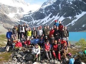
Students often attend workshops, conferences and summer schools in beautiful, remote locations. Taken at an advanced climate dynamics (ACDC) course in Northern Norway.
|
Research in the News
Here are links to a selection of articles for the general public related to my research:
- Watch a short video of our work on The Weather Channel
- Sea level rise: rapid and unstoppable unless Paris Agreement targets met
- Ice sheets on the move: how north and south poles connect
- Researchers examine how world-apart ice sheets influence each other
- Faculty Feature in The Sandbox
- Melting ice sheets may cause 'climate chaos' according to new modelling
- The Influence of Earth Deformation and Gravity on Future Antarctic Ice Loss
- Ice Sheets in Peril? Gravity to the Rescue
- Popsicle Earth
- Antarctic Ice Loss and Sea Level Rise
- Collapse of the West Antarctic Ice Sheet (1), (2), (3)
Sea-Level Change
One might think that if an ice sheet melts, sea level will rise evenly everywhere, as if the oceans were filling up like a bathtub. In reality, gravitational, Earth deformational and rotational effects following the retreat and advance of ice sheets and mountain glaciers lead to markedly non-uniform patterns of sea-level change. These patterns are often referred to as "sea-level fingerprints" because they are unique to the geometry and timescale of the changes in grounded ice distribution.
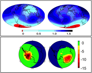
As an example, the figure on the right shows predictions of the sea-level change immediately following the rapid collapse of the West Antarctic Ice Sheet (left) and marine sectors of the East Antarctic Ice Sheet (right). The plots are normalized by the global average value of sea-level rise, so that they can be scaled up or down for any amount of ice sheet retreat. If you melted enough ice from the West Antarctic to raise sea level by 1 meters assuming that the melt water were spread evenly over the oceans, the US East Coast would actually see 1.35 meters of sea-level rise. Similarly, if you melted enough ice for 5 meters of global average sea-level rise, the US East Coast would see 6.5 meters of sea-level rise (top left plot). In general, the patterns are characterized by a greater-than-average sea level rise far away from the location of ice loss and a large sea-level fall in the vicinity of a retreating ice sheet (the opposite applies for an advancing ice sheet). The bottom plots show polar projections of the same fields in the top plots, zooming in on the region of ice loss.
Sea-level modeling can give insight into a wide variety of problems in climate and solid Earth science, including (but not limited to): understanding the response of the planet to ice-age and modern climate changes; predicting the contributions from ice sheet retreat to future sea-level rise; and processing and interpreting measurements of sea-level change, glacial isostatic adjustment and solid deformation.
RELATED PUBLICATIONS:
Powell, E., Gomez, N., Hay, C., Latychev, K. & Mitrovica, J. X.(2020). Viscous Effects in the Solid Earth Response to Modern Antarctic Ice
Mass Flux: Implications for Geodetic Studies of WAIS Stability in a Warming World. Journal of Climate. doi: 10.1175/JCLI-D-19-0479.1
Hay, C., Lau, H., Gomez, N., Austermann, J., Powell, E., Mitrovica, J. X., Latychev, K., and Wiens, D. (2017). Sea-level fingerprints in a region
of complex Earth structure: The case of WAIS. Journal of Climate, 30, 1881-1892. doi: 10.1175/JCLI-D-16-0388.1
Gomez, N., Gregoire, L.J., Mitrovica, J.X., Payne, A.J. (2015). Laurentide-Cordilleran Ice Sheet saddle collapse as a contribution to
meltwater pulse 1A, Geophys. Res. Lett., 42, doi: 10.1002/2015GL063960.
Hay, C., Mitrovica, J.X., Gomez, N., Creveling, J.R., Austermann, J. and Kopp, R.. (2014) The sea-Level Fingerprint of Ice-Sheet Collapse
During Interglacial Periods. Quat. Sci. Rev. 87: 60–69. doi: 10.1016/j.quascirev.2013.12.022.
Mitrovica, J.X., Gomez, N., Morrow, E., Hay, C., Latychev, K. and Tamisiea, M.E.. (2011) On the robustness of predictions of sea level
fingerprints. Geophys. J. Int. 187, 729-742. doi: 10.1111/j.1365-246X.2011.05090.x.
Gomez, N., Mitrovica, J.X., Tamisiea, M. and Clark, P.. (2009) A New Projection of Sea-Level Change in Response to a Collapse of the
Antarctic Ice Sheet. Geophysical Journal International. 180, 623-634. doi: 10.1111/j.1365-246X.2009.04419.x.
Mitrovica, J.X., Gomez, N., Clark, P. (2009) The Sea-Level Fingerprint of West Antarctic Collapse. Science. 323, 753. doi: 10.1126/science.1166510.
Ice Sheet - Sea Level - Solid Earth Interactions
Marine ice sheets like the West Antarctic ice sheet rest on bedrock that lies below the sea surface elevation and interact with the surrounding ocean. The ice loss across the grounding line of a marine ice sheet depends strongly on the depth of water there, such that if the grounding line retreats a little bit into deeper water, ice loss across the grounding line will increase leading to further, runaway retreat (see top frames of videos A and B below, showing a simplified, 1-D ice sheet-shelf model retreating down reversed beds with different reversed slopes). Past models of marine ice sheets have considered the impact of global average sea-level rise following ice-sheet retreat, but as we saw above, sea-level actually falls at the edge of a retreating ice sheet. Collaborators and I have shown that these gravitationally self-consistent sea-level changes have a stabilizing influence on marine ice sheets, acting to slow down and in some cases halt grounding line migration. The bottom frames below show simulations in which a sea-level coupling has been incorporated into the ice sheet model, demonstrating the slowdown (A) and halting (B) of the grounding line as compared to the upper frames in which no sea-level changes have been incorporated into the ice-sheet model.
|
(A) Simulation on a steeper reversed bedslope of -0.7 m/km in which the sea-level fall at the grounding line acts to compensate for some of the deepening of the bed, slowing down the ice sheet retreat.
|
(B) Simulation on a shallower reversed bedslope of -0.3 m/km in which the sea-level fall at the grounding line is large enough to fully compensate for the deepening of the bed and stop the ice-sheet retreat.
|
In recent work, we coupled a more realistic, 3-D ice sheet-shelf model to a global sea-level model that incorporates viscoelastic deformation of the solid Earth and applied the coupled model to simulate the evolution of the Antarctic Ice Sheet over the last deglaciation. These results demonstrated the stabilizing influence of the sea-level coupling in a more realistic setting, confirming the conclusions of our earlier work with simplified ice-sheet models. We can use the coupled ice sheet - sea level model as a tool to take an integrated view of the evolution of ice sheets, sea level and the solid Earth.
RELATED PUBLICATIONS:
Gomez, N., Latychev, K. and Pollard, D.. (2018) A coupled ice sheet-sea level model incorporating 3D Earth structure: Variations in
Antarctica during the last deglacial retreat. J. Climate, 31, 4041-4054. doi: 10.1175/JCLI-D-17-0352.1.
Pollard, D., Gomez, N., DeConto, R. and Han, H.. (2018) Estimating modern elevations of Pliocene shorelines using a coupled ice sheet-
Earth-sea level model. J. Geophys. Res. - Earth Surface. doi: 10.1029/2018JF004745.
Pollard, D., Gomez, N. and DeConto, R.. (2017). Variations of the Antarctic Ice Sheet in a coupled ice- sheet – Earth - sea level model:
sensitivity to viscoelastic Earth structure. J. Geophys. Res. Earth Surface., 122. doi: 10.1002/2017JF004371.
Gomez, N., Pollard, D., and Holland, D.. (2015) Sea-level feedback lowers projections of future Antarctic ice-sheet mass loss. Nature
Communications 6, 8798. doi: 10.1038/ncomms9798.
Gomez, N., Pollard, D., and Mitrovica, J.X.. (2013) A 3-D coupled ice sheet - sea level model applied to Antarctica through the last
40 ky. Earth Planet. Sci. Lett. 384, 88-99. doi: 10.1016/j.epsl.2013.09.042.
Gomez, N., Pollard, D., Mitrovica, J.X., Huybers, P. and Clark, P.U.. (2012) Evolution of a Coupled Marine Ice Sheet - Sea Level Model. J.
Geophys. Res. 117, 9 pp. doi: 10.1029/2011JF002128.
Gomez, N., Mitrovica, J.X., Huybers, P. and Clark, P.U.. (2010) Sea Level Change As a Stabilizing Influence on Marine Ice Sheets. Nature
Geoscience. 3, 850-853. doi: 10.1038/ngeo1012.
Implications of GIA and Climate Change For Arctic Canada
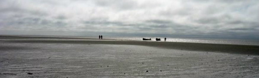
The location of future shorelines in Arctic Canada will impact the livelihood of native communities as well as their claim to land and resources. In the flat terrain of the Hudson Bay region (see the photo below, taken near Fort Albany, Ontario), future shoreline migration can be expected to occur due to both glacial isostatic adjustment associated with the last Ice Age and sea-level changes associated with ongoing melting of the polar ice sheets and mountain glaciers in response to future climate warming. Greenland ice loss would result in a small gradient of sea level fall across the bay, whereas Antarctic ice loss would cause a relatively uniform sea level rise. Changing sea levels in turn affect ocean tides, which are highly sensitive to changes in water depths. Tides in Hudson Bay are among the world's largest, thus the region is particularly interesting to study the interactions between sea level and tide changes. For her M.Sc., Anna-Mireilla Hayden investigated the impacts of future ice sheet retreat on sea level and tides in the region.
The publications below describe work I was involved in to model future shoreline migration in the Hudson Bay region, explore its impact on native coastal communities, and educate young native Canadians about these issues.
The publications below describe work I was involved in to model future shoreline migration in the Hudson Bay region, explore its impact on native coastal communities, and educate young native Canadians about these issues.
RELATED PUBLICATIONS:
Hayden, A.‐M., Wilmes, S.‐B., Gomez, N., Green, J. A. M., Pan, L., Han, H., & Golledge, N. R. (2020). Multi‐century impacts of ice sheet
retreat on sea level and ocean tides in Hudson Bay. Journal of Geophysical Research: Oceans, 125. e2019JC015104.
https://doi.org/10.1029/2019JC015104
Tsuji, L.J.S., Daradich, A., Gomez, N., Hay, C., and Mitrovica, J.X.. (2016). Sea-Level Change in the Western James Bay Region of Sub-Arctic
Ontario: Emergent Land and Implications for Treaty No. 9. Arctic, 69, 1, 99-107. doi: 10.14430/arctic4542
Karagatzides, J.D., Kozlovic, D.R., De Iuliis, G., Liberda, E.N., General, Z., Liedtke, J., McCarthy, D.D., Gomez, N., Metatawabin, D. &
Tsuji, L.. (2011) Youth Environmental Science Outreach in the Mushkegowuk Territory of Subarctic Ontario, Canada, Applied
Environmental Education & Communication, 10, 201-210. doi: 10.1080/1533015X.2011.669684
Tsuji, L., Gomez, N., Mitrovica, J. (2009) Post-Glacial Adjustment and Global Warming in Sub-Arctic Canada: Implications for Islands
of the James Bay Region. Arctic. 64, 24 pages. doi: 10.14430/arctic176
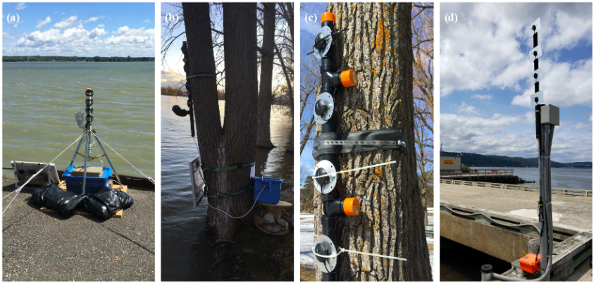
Coastal Sea-Level and Tidal Monitoring USING GNSS-IR
|
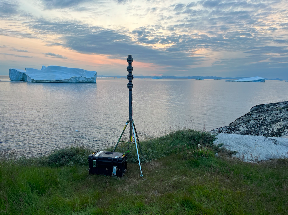
Future sea-level rise poses a threat to coastal communities and environments around the world and accurate monitoring of ongoing changes is needed, but observations are often sparse, especially in polar regions where traditional instruments such as tide gauges are not suited to the harsh, remote conditions. We have been developing and deploy monitoring systems use a technique called GNSS-interferometric reflectometry (GNSS-IR) where GNSS signals are analyzed that reflect off of the water surface before reaching an antenna installed on land next to the water. Rather than using expensive, research-grade GNSS antennas that were not designed for reflectometry, we have been exploring whether precise sea level measurements can be obtained by building a novel monitoring system with an array of much less expensive antennas. We have piloted these systems along the St. Lawrence river (Purnell et al., 2021), and our results suggest that a setup with several low-cost, simple to install antennas can measure water level changes more precisely than a more expensive set up. This approach has the potential to more densely monitor changing polar regions and global coastlines, generate new insights into the processes driving the changes and improve projections of future coastal change.
We encourage those interested in this technique to explore gnssrefl, an initiative led by Kristine Larson to develop an open source python-based software package for GNSS interferometric reflectometry with plenty of examples, videos and documentation. |
|
RELATED PUBLICATIONS:
David Purnell's PhD Thesis from McGill University (2022)
Purnell, D., Gomez, N., Minarik, W. and Langston, G. Real-time water levels using GNSS-IR: a potential tool for flood monitoring. Geophysical Research Letters (in review).
Purnell, D.J., Gomez, N., Minarik, W. and Porter, D. (2021). Precise water level measurements using low-cost GNSS antenna arrays. Earth Surf.Dynam., 9, 673-685. Link
Purnell, D.J., Gomez, N., Chan, N.H., Strandberg, J., Holland, D.H. and Hobiger, T. (2020). Quantifying the uncertainty in ground-based GNSS-Reflectometry sea level measurements. IEEE Journal of Selected Topics in Applied Earth Observations and Remote Sensing (JSTARS) doi: 10.1109/JSTARS.2020.3010413.
Energy and Environmental Issues
As a member of the Harvard Graduate Consortium on Energy and the Environment, I engaged in courses, seminars and research on the issues, consequences and strategies related to the future of energy and the environment. I am particularly interested in taking a broad, interdisciplinary perspective on topics related to climate change and sea-level rise, but I have also done research in other areas.
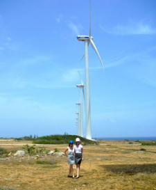
For example, I worked with Meredith Langstaff, another graduate student in the Consortium, to investigate the increase of renewable energy penetration in Aruba. In particular, we looked into ways to incentivize electricity load management technologies such as electric vehicles and electric thermal storage to accommodate intermittency issues associated with wind and solar energy. We had the opportunity to travel to Aruba to meet with many of the key players in the Energy and Government sectors and wrote a report for the Aruban Government on our work. An article from the Carbon War Room discusses Aruba’s progress towards renewable energy and sustainability.
NAVIGATE TO TOP OF PAGE